ALERT: THIS JUST IN, we are adding on as it comes in...... check it out get it out all over if possible, I do not care if you cut and paste this and do not give Vatic Project any notice or credit, it just needs to go viral before tomorrow. Thanks to "C" for sending this. Time is of the essence, remember, once exposed they don't go through with it and in this case it may cost us dearly not to expose it ASAP. Its about the Madrid fault. WE just published a blog before this one that shows the military now runs our government, and Congress is not involved in military decisions to invade or act on our behalf. Add that to this below and you can see they are COMPLETELY OUT OF CONTROL. THIS IS A MILITARY DICTATORSHIP NOW AS THE PREVIOUS ARTICLE SHOWS FROM THEIR OWN LIPS. Its the pentagon that has the cyberwarfare responsiblity in concert with MI6 and Mossad. On the article below they have taken out half the photos and most of the links. Just google the titles and you should get the links, I keep fixing it and they keep screwing it up so now its up to you to decide if you want to put in a few minutes to confirm these below by finding the links by title. THEY ARE THREATENING THE MADRID FAULT AGAIN, SO THAT IS WHY THIS HAS TO GO VIRAL. Its another false flag to attack our nation and divide it so it can be easily sectioned off militarily, and the section of the country this would occur in, is the most heavily armed, thus they can reduce the threats to them by negating the guns through flooding, deaths etc. Also the Sun acting the way it is, I believe, from the evidence, is because of this below, and its man made. Thanks again.
***
Lets hope these don't get lost in the fray. Chemtrails and haarp have been crazy for a week now, and during that time earthquakes have happened to the middle of the country. Remember the navy (space division) map of our revised coast line they printed sometime in the 90's? Well, coincidentally, that is where the major earthquake splitting up the country, is suppose to happen. Couldn't get their North American superhighway to pass, so this will have to do. Create another earthquake at the madrid fault line. eyes rolling upward.
~~~~~~~~~~~~~~~~~~~~~~~~~~~~~~
*** Boy they sure have messed with this one. Sorry. I am going to put what they cut out and put at the bottom after the copyright notice, right here for you to see before you then get into the remainder. They even cut out some of Zorgons comments. Wow, we must have really hit on something here.
~~~~~~~~~~~~~~~~~~~~~~~~~~~
CLEMENTINE, THE SATELLITE THE SIZE OF A MOON IN ORBIT AROUND SUN
Uploaded by americanbunker on Jun 26, 2011
The Clementine Satellite was NOT a NASA project... it was a Department of Defense Project with the US NAVY... and was part of the Star Wars program. (VN: Does project Bluebeam sound familiar? Is this part of that program?)
The Naval Research Laboratory
NRL was responsible for the design, manufacture, integration, and mission execution of the Clementine spacecraft for the Ballistic Missile Defense Organization. (VN: I believe they are using it to stoke the sun and create havoc and finialize the destruction of the USA and making it into a third world country.)
http://www.youtube.com/watch?feature=player_detailpage&v=QoEs68dYlEQ
~~~~~~~~~~~~~~~~~~~~~~~~~~
Department of Defense
Released 07-24-2006
Excerpt Question and Answer session (Congress)
Q: Where is Clementine now?
A: The spacecraft, as you know, from the name Clementine, is only supposed to be here for a short period of time and be lost and gone forever, so it was intended for a very short period of time after this lunar mission, did a rendezvous with the earth, and shortly after that was shifted by the moon's gravity and continued a flight which will bring it back near the earth about nine years from now. So it's an 11 year total flight around the sun. So basically it's moving like a little planet around the sun, and it will bring it back close to us in about nine years... It's two years since it left us so it will be another nine years before it's back. (2005) But it's not useful right now. The mission is finished. (VN: That is my concern, given no one ever tells us the truth, what is going on and what is its real mission at this point in time. It will be out there for another 3 years around the sun. Is that what we are seeing now?)
Q: But unlike it's namesake, it's not lost and gone forever. It will be back?
~~~~~~~~~~~~~~~~~~~~~~~~~~~~~~
VN: Now comes a more detailed look at the program in these two articles below. Very fascinating journey down the rabbit hole with tons of links, this has been collecting data since 1996 and the people knew nothing about it, scum bags:
Now this is a military site, so be warned.

The Clementine Mission (VN: so they say, but they do lie)
On January 25, 1994, the Deep Space Program Science Experiment (DSPSE) (better known as Clementine) was launched from Vandenberg Air Force Base, California, on a mission designed to test lightweight miniature sensors and advanced spacecraft components by exposing them, over a long period of time, to the difficult environment of outer space. In addition to testing the various sensors, Clementine was given the complex task of mapping the moon. The mission results were spectacular.
Clementine Lunar Map Now Available
The Clementine Lunar Map is a browser based map that uses a mosiac of the Clementine data set to display the Moon at a variety of resolutions. The Clementine Lunar Map also alows users to locate any of the named lunar features.
By implementing the "faster, cheaper, better" management approach, Clementine was able to move from conceptual design to launch in only 22 months and at a cost of 80 million dollars (including the launch and mapping operations). This was the first time this particular approach was used in a space program.
The costs of previous deep space missions had been significantly higher and took a great deal more time to develop. Between February 26 and April 22, 1994, Clementine was able to deliver more than 1.8 million digital images of the moon back to the Clementine ground network, including the NRL satellite ground-tracking station located in Maryland.
These images were quickly accessible to the general public via the Internet and World Wide Web. When scientists reviewed the data from Clementine, they made a major scientific discovery: the possible existence of ice within some of the moon's craters. This discovery was confirmed in early 1998 by NASA's Lunar Prospector.
The Pentagon announced on December 3, 1996, that radar data acquired by the Clementine spacecraft indicated ice in the bottom of a crater on the South Pole of the Moon. Although it is never lit by the Sun, there are a few images of the South Pole available for viewing.
The BMDO assigned responsibility for the Clementine spacecraft design, manufacture, integration, and mission execution to the Naval Research Laboratory (NRL). The Lawrence Livermore National Laboratory (LLNL) provided lightweight imaging sensors developed under the sponsorship of BMDO.
Clementine launched on a Titan IIG expendable launch vehicle from Vandenberg Air Force Base into Low Earth Orbit (LEO) in January 1994. During its two month orbit of the Moon it captured 1.8 million images of the Moons surface.
 |  |
| Southpole (1.4 MB) | Southpole with ice marked in blue (1.2 MB) |
| To download the images for viewing, right click (or click and hold if you are using a Macintosh) and select "Save Link As...". Viewing the images through your browser is possible by clicking each image below. However, please keep in mind that the images are large! | |
In 1994, President Clinton cited Clementine as one of the major national achievements in aeronautics in space. He stated "The relatively inexpensive, rapidly built spacecraft constituted a major revolution in spacecraft management and design; it also contributed significantly to lunar studies by photographing 1.8 million images of the surface of the Moon." The President was not alone in his praise of Clementine. In addition to the President's comments, Clementine and the people associated with the program were presented with the following awards:
- Popular Science magazine: Best of 1994's Top 100 Technologies
- Aviation Week and Space Technology: 1994 Laureate Award
- National Space Club: Nelson P. Jackson Award
- Rotary National Award for Space Achievement
- Navy Award for Group Achievement
- Discover magazine: 1994 Award for Outstanding Technological Innovation
- 1996 Induction into the Space Hall of Fame
In 2003, NRL donated the engineering model of the Clementine satellite for display at the Smithsonian Institution's National Air and Space Museum in Washington, DC.
Processed Imagery
- Albedo Map of the Moon. About 50,000 Clementine images have been processed and mosaicked to produce a global map of the Moon's albedo - normalized brightness or reflectivity. (7/13/99)
- 42 Selected Images of the Moon and the Earth (posted 5/18/94)
- A Clementine Collection, the catalog accompanying the exhibit of Clementine imagery that opened at the National Academy of Sciences is available on-line. All the images of the moon and earth are available at viewing resolutions as well as full publication quality resolutions.
- Animation created from Clementine data.
Clementine Data Set
- The Clementine Lunar Map 2.0 (Beta) is available. The Clementine Lunar Image Browser has been transformed and renamed with the release of this browser based map.
- The Clementine Lunar Image Browser (CLIB) Version 1.5 has been retired. Version 1.5 allows access to over 170,000 Clementine images and includes a new interface that allows the user to zoom in to any location on the moon.
- The Lunar Feature Extension allows the user to make any of the over one thousand named lunar features the starting image in the Clementine Lunar Image Browser.
Links
~~~~~~~~~~~~~~~~~~
Naval Research Laboratory
NRL was responsible for the design, manufacture, integration, and mission execution of the Clementine spacecraft for the Ballistic Missile Defense Organization. (Watch the video)
NRL was responsible for the design, manufacture, integration, and mission execution of the Clementine spacecraft for the Ballistic Missile Defense Organization. (Watch the video)
~~~~~~~~~~~~~~~~~~~~~~~~~~~~
Wherefore Art Thou Clementine? The Mystery of Clementine Explored - Science Fiction or Truth?
.
.
Courtesy NASA/JPL
|
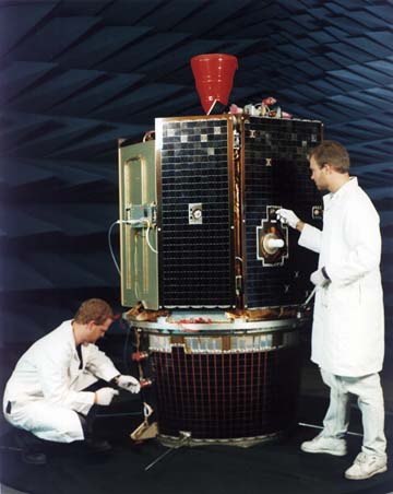
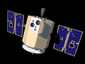
The Clementine Satellite
The Clementine satellite tested 23 advanced technologies during its mission for the Ballistic Missile Defense Organization. (VN: remember, that is a failed project (star wars), so what was the real purpose?) In fulfilling its scientific goals, Clementine provided a wealth of information relevant to the mineralogy of the lunar surface. Using six on-board cameras designed and built at the Laboratory, Clementine mapped the entire surface of the Moon at resolutions never before attained. Clementine also provided range data that will be used to construct a relief map of the lunar surface.
The first U.S. satellite to the Moon in more than two decades was launched from Vandenberg Air Force Base (Santa Barbara County), California, on January 25, 1994. The satellite was named Clementine because it carried only enough fuel to complete its mission before it was "lost and gone forever," as in the old ballad "My Darling Clementine."
The satellite orbited the Moon for more than two months beginning February 19, 1994 taking and transmitting high-resolution pictures and range data until it built up a detailedmap of the entire lunar surface. Clementine completed its lunar orbit on May 3, 1994, sending back more than 1.5 million images of the Moon.
Clementine's primary mission was to demonstrate in the harsh environment of space advanced, lightweight technologies developed by the Department of Defense for detecting and tracking ballistic missiles. (VN: or for ensuring its integrity during extended space flight around the sun, remember there is an article out today about an unidentified object the size of a moon that is drawing energy in large quantities off the sun and doing what with it??? Redirecting it to earth maybe as CME's? Is this our Clementine? Was that the mission? To destroy or seriously affect our electromagnetic shield? Cause global warming? Cause an Ice age? Cause famine and riots?? Who knows, but the questions must be asked since lying is the new standard constant that we can count on from these zionist bankers. In fact, they are proud of their ability to deceive the goyim cattle, which is us!)
Excerpt...
Clementine completely mapped the lunar surface in 14 discrete spectral bands ranging
from the near ultraviolet (0.415 µm), through the visible spectrum, to the far infrared (9.5 µm).
Excerpt...
The last phase of the scheduled mission was to be a flyby of the near-Earth asteroid Geographos, which is about 5 km long and crosses Earth's orbit about every 18 months. Even though near-Earth asteroids tend to be much larger than missiles, Geographos would have provided a meaningful target as Clementine attempted a near-miss intercept using the new sensor technologies.
Excerpt... After successfully mapping the Moon, Clementine left lunar orbit and began its journey to Geographos on May 5. On May 7, however, one of the on-board processors failed and turned on the attitude-control thrusters, which sent the spacecraft into a spin (81 revolutions/minute). That failure drained the attitude-control system of its fuel (although there was still fuel for the main thruster), effectively canceling the Geographos portion of the mission. At this angular velocity, Clementine could still have flown to Geographos, but it would not have sent back useful images, and contact with it probably would have been lost. As a result, Clementine spent its final days orbiting Earth, continuing to collect lifetime data on the new on-board technologies.
VISIBLE LIGHT {Normal Light}
High-Resolution Camera
This 1.1-kg camera operates at visible wavelengths (0.415 to 0.75 µm) with silicon CCD technology combined
with a compact, lightweight image intensifier.
with a compact, lightweight image intensifier.
To provide reliable, solid-state, cost-effective imaging in the near ultraviolet,
visible, and near-infrared regions of the spectrum (from 0.3 to 1.0 µm), LLNL designed and built a medium-resolution, 0.426-kg camera that uses silicon charge-coupled device
(CCD) technology. For Clementine, this camera was combined with a six position spectral filter wheel for remote sensing applications and, specifically, for mineral typing studies of the Moon. The image below shows the African continent imaged by the ultraviolet/visible camera at five different wavelengths on a clear day from a distance of 384,000 km.
 |
The above excerpts are taken from a PDF file on the Clementine Mission
provided courtesy of the Department of Defense's Ballistic Missile Defense Organization.
Comments: What I don't understand here is that the satellite left the moon May 5th on a path to the asteroid Geographos. Two days later on May 7th, it malfunctioned and lost the fuel for atitude control, and went into a spin. It had main thruster fuel. So how did a satellite spinning at 81 rpm manage to manuever out of its path to the asteroid and return to Earth, enter a stable geocentric orbit, and continue to take images over Earth?
Also the mission to the asteroid was scrubbed because the images wouldn't be useful (due to the spin?), but after this miraculous feat of returning to earth without an attitude-control system, insertion into orbit, and now its taking okay pictures of the Earth?
I am no rocket scientist, perhaps I am missing something - Zorgon
This report also contains complete and irrefutable proof that they had the equipment to take visible light natural color images and did! See further below for images of the Earth taken by the same cameras in full natural color while in transit and looking back on arrival - Zorgon
~~~~~~~~~~~~~~~~~~~~~~
The Clementine Mission: Initial Results from Lunar Mapping
Excerpt:
After mapping the Moon, Clementine departed for a flyby of the asteroid 1620 Geographos on 3 May 1994. After a few days, while rehearsing the datacollection sequence for the asteroid flyby, a software fault resulted in the firing (until fuel depletion) of the attitude-control thrusters. The spacecraft was spun up to over 80 rpm and could not be de-spun. Thus, the asteroid portion of the mission was cancelled. After flying near the Moon on 20 July 1994, Clementine went into solar orbit: it is hoped that renewed contact with the spacecraft can be established, in which case we will collect engineering data to Earth so that we can monitor the health and degradation of its sensors in a deep-space, hard-radiation environment.
Comments: According to NASA this report says it left the Moon on May 3rd, then after the malfunction it went into a spin that could not be stopped. Yet it returns to fly past the Moon on July 20, 1994 then goes into a solar orbit... where they hope to be able to re-establish contact. In otherwords IT'S STILL THERE
(VN: They took out the photos, so go to the various links. Keep this blog and I will try to refind those photos and do them up again, but it will take days to do. Sorry, but they do not want us to know about the moon and why they intend to destroy it.)
USGS Photo of Earth and Moon
.
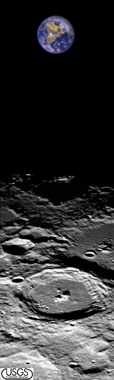 |
This is a composite photo using the Blue Earth image taken with the medium resolution camera on board Clementine. The earth is actually two times higher than the image shows and the black and white moon image was added as a dramatic promotional image. The Earth in this image is also enhanced and enlarged. {Compare to the original above}
A note below the image even states that; "The Earth actually appeared about twice as far above the lunar horizon as shown."
Credit: NRL
|
Clementine was launched January 25, 1994, as a joint project between the Strategic Defense Initiative Organization and NASA. The objective of the mission was to test sensors and spacecraft components under extended exposure to the space environment and to make scientific observations of the Moon and a near-Earth asteroid (1620 Geographos). Due to a malfunction on May 7th, 1994, Clementine exhausted its fuel after the successful mapping of the lunar surface, and did not complete the visit to the asteroid.
SOURCE: Astrogeology USGS
Comments:
This report says it EXHAUSTED its fuel... - Zorgon
Naval Research Laboratory The Pentagon announced on December 3, 1996, that radar data acquired by the Clementine spacecraft indicated ice in the bottom of a crater on the South Pole of the Moon. Although it is never lit by the Sun, there are a few images of the South Pole available for viewing.
Comments:
This report has Clementine acquiring radar data in December 1996 - Zorgon
Scientific Visualization Studio
.
The Image below has been posted here by others as representing a true image of Aristarchus Crater taken by the Hubble Space Telescope... This is incorrect...
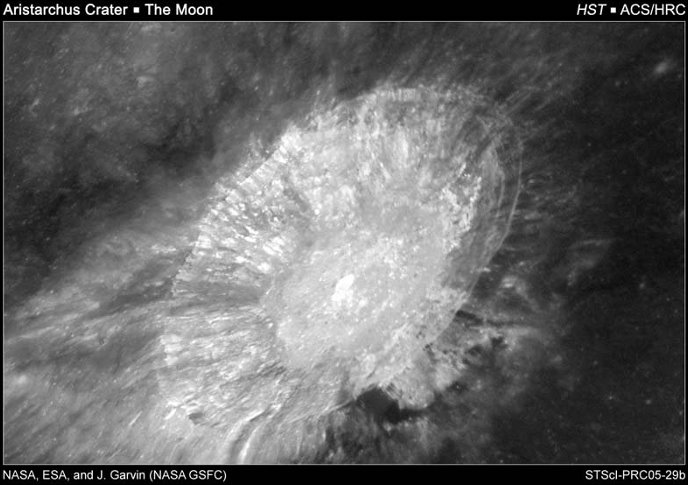 |
The above image was created by J.Garvin and his team. It is a composite image that is one frame of an animation. Below is the relevant data. You can compare the name on the image to those below. HST imagery of Aristarchus Crater draped over simulated topography
Animators:
Greg Shirah (Lead)
Alex Kekesi
Greg Bacon
Studio: SVS
Completed: 2005-10-12
Scientist: James Garvin (NASA/GSFC)
Instruments:
HST/ACS
Clementine/HIRES
Data Collected:
HST: 2005/08/16 - 2005/08/21;
Clementine:1998/02/07-1999/06/25
This source seems to indicate that there was new Data from Clementine from 1998 to 1999 - Zorgon
USGS Flagstaff
The following link is dead... found this in a cache file...
Task Force Report: Annex D Clementine
launched 1994
1. map Moon;
2. visit Earth-crossing asteroid 1620 Geographos (but booster failed).
[Clementine 2 planned but on hold]
Comments:
Okay, this one says booster failure not fuel shortage.... on hold not vetoed... - Zorgon
NASA NSSDC National Space Science Data Center
.
Credit: NASA NSSDC
|
Excerpt
Clementine was a joint project between the Ballistic Missile Defense Organization (BMDO, nee the Strategic Defense Initiative Organization, or SDIO) and NASA. The objective of the mission was to test sensors and spacecraft components under extended exposure to the space environment and to make scientific observations of the Moon and the near-Earth asteroid 1620 Geographos. The Geographos observations were not made due to a malfunction in the spacecraft. The lunar observations made included imaging at various wavelengths in the visible as well as in ultraviolet and infrared, laser ranging altimetry, gravimetry, and charged particle measurements....
Excerpt
Unfortunately, on May 7, 1994, after the first Earth transfer orbit, a malfunction aboard the craft caused one of the attitude control thrusters to fire for 11 minutes, using up its fuel supply and causing Clementine to spin at 80 rpm. Under these conditions, the asteroid flyby could not yield useful results, so the spacecraft was put into a geocentric orbit passing through the Van Allen radiation belts to test the various components on board. The mission ended in June 1994 when the power level onboard dropped to a point where the telemetry from the spacecraft was no longer intelligible.
Comments:
This NASA site has another variation of the story of Clementine. Now its not only taking photos of the Earth but studying the Van Allen Belt. DoD says 81 rpm, NASA says 80 rpm. Okay that is a small nit-picking amount I know, BUT these guys are rocket scientists, with the best computers, in a field where the slightest miscalculation could have drastic results... surely they could have their reports in agreement with each other?
This report ends Clementine June 1994. This one also says that Clementine was part of Strategic Defense Initiative Organization or "Star Wars" as it was called. - Zorgon
President Clinton Clementine I
In 1994, President Clinton cited Clementine as one of the major national achievements in aeronautics in space. He stated "The relatively inexpensive, rapidly built spacecraft constituted a major revolution in spacecraft management and design; it also contributed significantly to lunar studies by photographing 1.8 million images of the surface of the Moon." The President was not alone in his praise of Clementine. In addition to the President's comments, Clementine and the people associated with the program were presented with the following awards:
* Popular Science magazine: Best of 1994's Top 100 Technologies
* Aviation Week and Space Technology: 1994 Laureate Award
* National Space Club: Nelson P. Jackson Award
* Rotary National Award for Space Achievement
* Navy Award for Group Achievement
* Discover magazine: 1994 Award for Outstanding Technological Innovation
* 1996 Induction into the Space Hall of Fame
President Clinton Clementine II
27 October 1997 NEWS RELEASE:
The National Space Society was disappointed to learn of President Clinton's recent line-item vetos of several small military space programs. The Clementine 2 asteroid intercept mission, as with Clementine 1, would have been the most cost-effective approach to combining important technology demonstrations with real scientific missions.
SOURCE
Comments:
The President praises and awards the Clementine I efforts but vetos launch of Clementine II. There is no Clementine II that we know of that would account for the discrepencies - Zorgon
Minor Reports
After 1976, the Moon was ignored by space probes until the U.S. Department of Defense's new Strategic Defense Initiative Organization (SDIO, aka "Star Wars") flew the Clementine 1 probe to map the Moon's surface with modern instruments, in conjunction with NASA. Clementine 1 arrived at the Moon in February 1994...
Clementine 1 entered a polar orbit around the Moon in order to map its entire surface. Clementine 1 orbited the Moon for more than two months, totalling over 300 orbits, from February 19 to May 5, 1994. Clementine 1 left lunar orbit to rendezvous with near Earth asteroid 1620 Geographos, but a computer malfunction caused the spacecraft to fail before it reached the asteroid...
Comment:
This one says Clementine was part of Star Wars, left lunar orbit and was a COMPUTER MALFUNCION. This report is adapted from the one below... -Zorgon
{Above link gives me "The connection has timed out"}
{This one also says computer but the document is under subscription only}
Clementine France
CLEMENTINE can be found in the following categories: Space & Earth Science
NORAD ID: 25978
Int'l Code: 1999-064B
Perigee: 607 km
Apogee: 620 km
Inclination: 98.3°
Period: 97 min
Launch date: 1999-12-03
Source: France (FR)
Comments: Intelligence gathering, part of an experimental eavesdropping program.
Clementine France
NSSDC ID: 1999-064B
Other Names: * 25978
Launch Date/Time: 1999-12-03 at 16:22:00 UTC
On-orbit Dry Mass: 50 kg
Description
Clementine France was a research satellite designed to study the Earth's radio-electric environment.
Discipline: Space Physics
Sponsoring Agency/Country: Unknown/France
Comments:
A new Clementine... designened for science, but used for spying, by an unknown agency, launched in Dec 1999 (6 months after last "sighting" of Clementine I{see above})
Okay sure why not? Nothing odd about that... _Zorgon
Albedo Map of the Moon U.S. Geological Survey This provides the best albedo map produced to date for most of the far side. Although the images were acquired at a resolution of about 100 meters/pixel, they have been reduced to 1 km/pixel for this preliminary effort. Last Updated 10/19/2000 05:53:29
Comments:
This is the first version of the Clementine mosaic available to the public. They are in blackand white and 1 meg in size. Date created Jul 17,2000 - Zorgon
Clementine Lunar Image Browser 1.5
Clementine captured 1.8 million images of the Moon's surface. The Laboratory provides the Clementine Lunar Image Browser as a courtesy to scientific researchers, as well as the general public, and you are welcome to browse the over 170,000 images that are available.
Comments:
This version was at the same time...Only one tenth of the images taken reached the public. Since we know they mapped the entire moon, you can see how much of the area we cannot view. Last Updated 10/15/2003 06:21:19
Clementine Lunar Image Browser 1.5l
New version of the Navy Browser Last updated 01/31/2006 10:52:01
Comments: Now available through NASA, CD's of Clementine images, all 1.8 million but they are only in black and white - Zorgon
CLEMENTINE - USGS IMAGES
Here are two more images from the sUSGS proving once and for all that the camera on board Clementine CAN AND DOES take real, normal, visible light spectrum images. The images below were taken while Clementine was on its way to the moon.


The article is reproduced in accordance with Section 107 of title 17 of the Copyright Law of the United States relating to fair-use and is for the purposes of criticism, comment, news reporting, teaching, scholarship, and research.
Links
No comments:
Post a Comment